EarthToMC v1.1beta changelog:
Dear friends, in just a few days it will have been a year since I released my first real-world map for Minecraft. In a short time, this little project grew into something much bigger: thanks to everyone’s enthusiasm and positive feedback, my goal became to develop—completely from scratch—a ...
2025-01-18 19:01:44 +0000 UTC
View Post
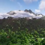
Here come the worldpainter project files of the map of the United States of America at 1:250 scale with biomes, vegetation and other natural features derived from OpenStreetMap and NLCD Land Cover data
Map images:
 2024-08-27 07:51:05 +0000 UTC
View Post
2024-08-27 07:51:05 +0000 UTC
View Post

This work is a representation of the contiguous United States of America, part of Canada, Mexico, Cuba and Bahamas on a 1:250 scale for Minecraft
Features
 This work is a representation of Warren County, VA, USA and neighbrood areas, on a 1:1 scale for Minecraft
Features
Here come the worldpainter project files of the map of Warren County, VA, USA at 1:1 scale with buildings, roads, biomes, vegetation and other natural features derived from OpenStreetMap and NLCD Land Cover data
Map image:
 2024-08-26 07:11:37 +0000 UTC
View Post
2024-08-26 07:11:37 +0000 UTC
View Post

This work is a representation of El Paso, TX, USA and neighbrood areas, on a 1:1 scale for Minecraft
Features
Here come the worldpainter project files of the map of El Paso, TX, USA and neighbrood areas at 1:1 scale with buildings, roads, biomes, vegetation and other natural features derived from OpenStreetMap and NLCD Land Cover data
Map image:
 2024-08-26 06:52:28 +0000 UTC
View Post
2024-08-26 06:52:28 +0000 UTC
View Post
Thank you for subscribing the Top Tier membership!
Here come the worldpainter project files of the map of Vacaville, CA, USA and neighbrood areas at 1:1 scale with buildings, roads, biomes, vegetation and other natural features derived from OpenStreetMap and NLCD Land Cover data
...
2024-08-22 08:13:45 +0000 UTC
View Post

This work is a representation of Vacaville, California, USA and neighbrood areas, on a 1:1 scale for Minecraft
Features

This work is a representation of Ocean City, MD, USA and neighbrood areas, on a 1:1 scale for Minecraft
Features
Thank you for subscribing the Top Tier membership!
Here come the worldpainter project files of the map of Ocean City, MD, USA and neighbrood areas at 1:1 scale with buildings, roads, biomes, vegetation and other natural features derived from OpenStreetMap and NLCD Land Cover data
2024-08-21 06:20:32 +0000 UTC
View Post

This work is a representation of Jackson and neighbrood areas, Mississippi, USA, on a 1:1 scale for Minecraft
Features
Thank you for subscribing the Top Tier membership!
Here come the worldpainter project files of the map of Jackson and neighbrood areas, Mississippi, USA, at 1:1 scale with buildings, roads, biomes, vegetation and other natural features derived from OpenStreetMap and NLCD Land Cover data
2024-08-21 00:14:41 +0000 UTC
View Post
Thank you for subscribing the Top Tier membership!
Here come the worldpainter project files used to make the map of Honolulu and the entire island of O'ahu, Hawaii, USA, at 1:1 scale [64k] , with buildings, roads, biomes, vegetation and other natural features derived from OpenStreetMap and...
2024-08-16 03:11:12 +0000 UTC
View Post

This work is a representation of Honolulu and the entire Island of Oaho, Hawaii, USA, on a 1:1 scale for Minecraft
Features

This work is a representation of Jersey City and the Hudson County, NJ, USA, on a 1:1 scale with buildings, roads, trees, and vegetation derived from OpenStreetMap.
Individual trees within the cities will be present in-game, if trac...
2024-07-24 10:20:24 +0000 UTC
View Post
Thank you for subscribing the Top Tier membership!
Here come the worldpainter project files and the raw tif data used to make the map of Jersey City & Hudson County, NJ, USA, at 1:1 scale [11k] , with buildings, roads, biomes, vegetation and other natural features derived from OpenStre...
2024-07-24 10:09:45 +0000 UTC
View Post

This work is a representation of Hamilton, NY, USA, on a 1:1 scale with buildings, roads, trees, and vegetation derived from OpenStreetMap.
Individual trees within the cities will be present in-game, if traced on OpenStreetMa...
2024-07-24 08:04:30 +0000 UTC
View Post
Thank you for subscribing the Top Tier membership!
Here come the worldpainter project files and the raw tif data used to make the map of Hamilton, NY, USA, at 1:1 scale [8k] , with biomes, vegetation and other natural features derived from OpenStreetMap and NLCD Land Cover data
<...
2024-07-24 07:54:11 +0000 UTC
View Post

This work is a representation of the State of Mississippi, USA, on a 1:20 scale with biomes, vegetation and other natural features derived from OpenStreetMap and high resolution land cover datasets
Thank you for subscribing the Top Tier membership!
Here come the worldpainter project files and the raw tif data used to make the map of Mississippi, USA, at 1:20 scale [27k] , with biomes, vegetation and other natural features derived from OpenStreetMap and NLCD Land Cover data
...
2024-07-20 15:47:08 +0000 UTC
View Post

This work is a representation of the State of Hawaii, USA, on a 1:10 scale with biomes, vegetation and other natural features derived from OpenStreetMap and high resolution land cover datasets
Thank you for subscribing the Top Tier membership!
Here come the worldpainter project files and the raw tif data used to make the map of Hawaii, USA, at 1:10 scale [51k] , with biomes, vegetation and other natural features derived from OpenStreetMap and NLCD Land Cover data
<...
2024-07-16 08:51:40 +0000 UTC
View Post

This work is a representation of Baden District, Austria, on a 1:1 scale with buildings, roads, trees, and vegetation derived from OpenStreetMap.
Individual trees within the cities will be present in-game, if traced on OpenS...
2024-07-11 02:26:37 +0000 UTC
View Post
Thank you for subscribing the Top Tier membership!
Here come the worldpainter project files and the raw tif data used to make the map of Baden District, Austria, at 1:1 scale [25k] , with buildings, roads, trees and other natural features derived from OpenStreetMap and GLC FCS 30 Land Cove...
2024-07-11 02:16:56 +0000 UTC
View Post

This work is a representation of the city of Kansas City, Missouri, on a 1:1 scale with buildings, roads, trees, and vegetation derived from OpenStreetMap.
Starting from this map, individual trees within the cities will be present in-game,...
2024-06-17 10:48:58 +0000 UTC
View Post
Thank you for subscribing the Top Tier membership!
Here come the worldpainter project files and the raw tif data used to make the map of Kansas City at 1:1 scale [45k] , with buildings, roads, trees and other natural features derived from OpenStreetMap and NLCD Land Cover data
2024-06-17 10:23:42 +0000 UTC
View Post
Thank you for subscribing Top Tier membership!
Here come the details of the data used to make the map of the entire state of Florida at 1:20 scale, with natural features from OpenStreetMap and Land Cover data [45k]
Biomes images:
...
2024-06-05 01:38:46 +0000 UTC
View Post

Welcome to my new project! This map contains the entire state of Florida, USA, with a scale of 1:20 (one block in the game corresponds to 20m in the real world).
The positioning of biomes is entir...
2024-06-05 00:44:37 +0000 UTC
View Post